MADISON, Wis. (CIVIC MEDIA) – An improvement from last year as arctic air spills in again, creating sea smoke and ideal conditions for big bodies of water to freeze.
With open waters on the Great Lakes and plenty of cold air spilling in across them, bouts of lake-effect snow has been triggered across northern Wisconsin and into the Upper Peninsula of Michigan. Which is good news for snowmobile trails and businesses located along them.
After the Great Lakes were historically warm to end 2024, this winter’s deep chill took its sweet time pushing in. Now that it’s got a tight grip on us, ice is rapidly in the making.
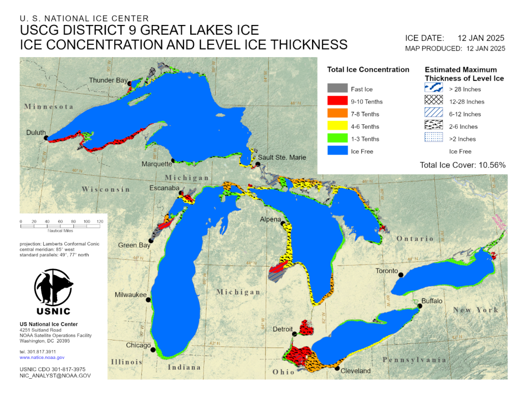
The lakes began 2025 with a basin-wide ice coverage of just 1.24%.
As of January 12th, we spiked to 10.56%. After this current cold snap, forecasts suggest it’ll be near 15% coverage. The average ice coverage for this time of year is typically 17%.

Consistently frigid temperatures are needed for surface ice to build across the basin.
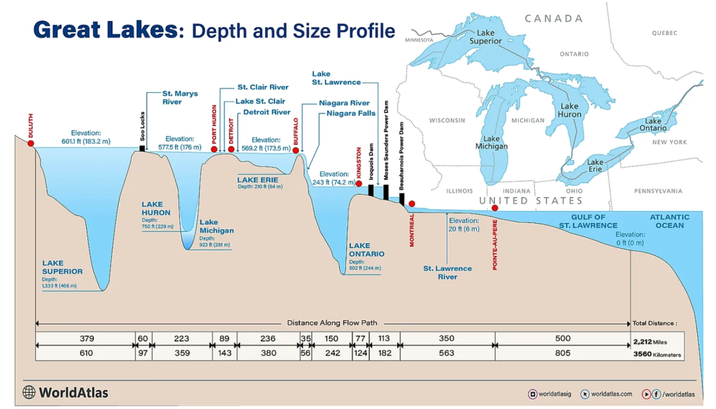
Shallower lakes are the first to freeze over, including Erie and Huron. While the larger and deeper lakes hold onto their heat longer into the winter.

Record-warm temperatures across the region in 2024 kept the Great Lakes ice to a minimum last winter. Data collected by NOAA put the maximum ice coverage in 2024 reaching just 16% on Jan. 22. Marking the lowest extent of ice recorded in more than a decade.
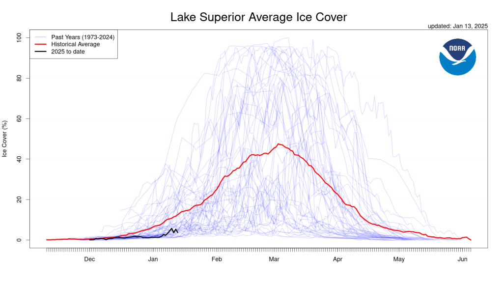
The two Great Lakes surrounding our state, the deepest one of them all, Lake Superior. Currently, the south shore is freezing over, with Chequamegon Bay completely covered.

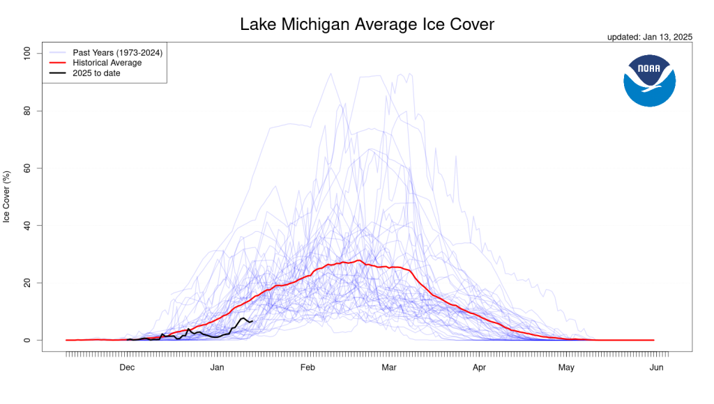
On Lake Michigan, mainly the Bay of Green Bay is icing up. Keep in mind though that the Coast Guard still goes through breaking up the ice there until the Soo Locks freeze over and shipping stops. The Soo Locks typically close January 15th to March 25th, but may stay open longer or open earlier depending on ice conditions. This is important to note as winds may shift ice sheets, leaving anglers stranded and in danger needing to be rescued.

There’s a few reasons why ice coverage on the Great Lakes matters.
First, evaporation in the form of sea smoke. What’s happening is the layer of warm water on the surface is being cooled rapidly by the arctic air mass and condenses, forming vapor. This slowly reduces the amount of water in the lake. So if the water is frozen, it’s locked it.
Plus, towns like Hurley in northern Wisconsin want a break from the relentless snow, especially by February. They typically see 200″ of snowfall a season. Because every time the winds blow in cold from the north, certain areas are hit hard with a mini snow storm off the lake. It’s called lake effect snow. Once the waters freeze over though, the snowfall stops.
In a sense, the ice is a buffer from powerful winter storms. Especially stopping massive waves from destroying lakeshores. Winds in systems are at their strongest when the temperatures from the pole to the equator are at their biggest difference, in winter.
Civic Media Inc.
Put us in your pocket.